![](/images/other/stat-length.png)
![Trail On foot Neukirchen beim Heiligen Blut - R 4 »Wasserscheidenweg« - Photo](https://media.geolcdn.com/t/1900/400/ext.pjpeg?maxdim=2&url=https%3A%2F%2Fstatic1.geolcdn.com%2Fsiteimages%2Fupload%2Ffiles%2F1545311037marcheuse_200dpi.jpg)
R 4 »Wasserscheidenweg«
SityTrail - itinéraires balisés pédestres
Tous les sentiers balisés d’Europe GUIDE+
![Length](/images/other/stat-length.png)
Length
6.8 km
![Max alt](https://static1.geolcdn.com/siteimages/upload/files/1508320355ic_sort_altitude_max_24dp.png)
Max alt
1084 m
![Uphill gradient](https://static1.geolcdn.com/siteimages/upload/files/1508320355ic_sort_den_pos_24dp.png)
Uphill gradient
307 m
![Km-Effort](/images/other/stat-length.png)
Km-Effort
10.9 km
![Min alt](https://static1.geolcdn.com/siteimages/upload/files/1508320355ic_sort_altitude_min_24dp.png)
Min alt
779 m
![Downhill gradient](https://static1.geolcdn.com/siteimages/upload/files/1508320355ic_sort_den_neg_24dp.png)
Downhill gradient
308 m
![Boucle](https://static1.geolcdn.com/siteimages/upload/files/16400158638029165_repeat_loop_refresh_sync_direction_icon.png)
Boucle
Yes
Signpost
Creation date :
2022-02-11 13:23:18.971
Updated on :
2022-02-11 13:23:18.971
![On foot](https://static1.geolcdn.com/sitytour/trail-icons/100.png)
2h28
Difficulty : Easy
![Scan this QR Code to open this trail in the SityTrail application](https://capi.geolives.com/qq0zvz2zws4bq2lad0pu/sitytour/trails/3090154/qr.png?size=200)
FREE GPS app for hiking
About
Trail On foot of 6.8 km to be discovered at Bavaria, Landkreis Cham, Neukirchen beim Heiligen Blut. This trail is proposed by SityTrail - itinéraires balisés pédestres.
Description
Symbol: Schwarze Wegnummer im weißen Bereich des oben weißen / unten roten, rechteckigen Hintergrunds
Positioning
Country:
Germany
Region :
Bavaria
Department/Province :
Landkreis Cham
Municipality :
Neukirchen beim Heiligen Blut
Location:
Unknown
Start:(Dec)
Start:(UTM)
358269 ; 5456014 (33U) N.
Comments
Trails nearby
![Trail On foot Hamry - [M] Nýrsko - U Zadních chalup - Photo](https://media.geolcdn.com/t/375/260/b0f51d5c-6d8f-4cc1-a603-97fa4a19a981.jpeg&format=jpg&maxdim=2)
![On foot On foot](https://static1.geolcdn.com/sitytour/trail-icons/100.png)
[M] Nýrsko - U Zadních chalup
On foot
Easy
Hamry,
Southwest,
Plzeňský kraj,
Czech Republic
![](/images/other/stat-length.png)
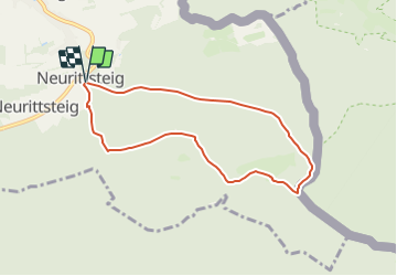
7.8 km | 10.7 km-effort
2h 25min
![](https://static1.geolcdn.com/siteimages/upload/files/16400158638029165_repeat_loop_refresh_sync_direction_icon.png)
No
![Trail On foot Lam - L 3 Lam - Osser (Osser-Riesensteig) - Photo](https://media.geolcdn.com/t/375/260/d755e85e-340b-44f3-a7ce-860e3e150c9e.jpeg&format=jpg&maxdim=2)
![On foot On foot](https://static1.geolcdn.com/sitytour/trail-icons/100.png)
L 3 Lam - Osser (Osser-Riesensteig)
On foot
Easy
Lam,
Bavaria,
Landkreis Cham,
Germany
![](/images/other/stat-length.png)
3.4 km | 6.6 km-effort
1h 29min
![](https://static1.geolcdn.com/siteimages/upload/files/16400158638029165_repeat_loop_refresh_sync_direction_icon.png)
No
![Trail On foot Lam - La 1 Lam - Osser (Künischer Grenzweg) - Photo](https://media.geolcdn.com/t/375/260/0c66b4d2-1a83-4e3d-a6fc-f5c33503c4c0.jpeg&format=jpg&maxdim=2)
![On foot On foot](https://static1.geolcdn.com/sitytour/trail-icons/100.png)
La 1 Lam - Osser (Künischer Grenzweg)
On foot
Easy
Lam,
Bavaria,
Landkreis Cham,
Germany
![](/images/other/stat-length.png)
5.9 km | 9.8 km-effort
2h 13min
![](https://static1.geolcdn.com/siteimages/upload/files/16400158638029165_repeat_loop_refresh_sync_direction_icon.png)
No
![Trail On foot Lam - LP Lamer Panoramaweg - Photo](https://media.geolcdn.com/t/375/260/e25ed577-2416-4f93-9100-e7f7f39724fa.jpeg&format=jpg&maxdim=2)
![On foot On foot](https://static1.geolcdn.com/sitytour/trail-icons/100.png)
LP Lamer Panoramaweg
On foot
Easy
Lam,
Bavaria,
Landkreis Cham,
Germany
![](/images/other/stat-length.png)
5 km | 7.4 km-effort
1h 41min
![](https://static1.geolcdn.com/siteimages/upload/files/16400158638029165_repeat_loop_refresh_sync_direction_icon.png)
No
![Trail On foot Lam - L 5 Lam - Hoher Riegel - Tanneneck - Photo](https://media.geolcdn.com/t/375/260/ext.jpg?maxdim=2&url=https%3A%2F%2Fstatic1.geolcdn.com%2Fsiteimages%2Fupload%2Ffiles%2F1545311037marcheuse_200dpi.jpg)
![On foot On foot](https://static1.geolcdn.com/sitytour/trail-icons/100.png)
L 5 Lam - Hoher Riegel - Tanneneck
On foot
Easy
Lam,
Bavaria,
Landkreis Cham,
Germany
![](/images/other/stat-length.png)
4.6 km | 6.5 km-effort
1h 28min
![](https://static1.geolcdn.com/siteimages/upload/files/16400158638029165_repeat_loop_refresh_sync_direction_icon.png)
No